We specialise in several key areas:
- Measured Building and Topographical Surveys: These surveys involve measuring and mapping the features of a building or a piece of land. Measured building surveys focus on the details of a building's structure, while topographical surveys map the contours and features of the land. We utilise Emlid GNSS receivers in our topographical surveys to deliver high-accuracy data collection. GNSS technology ensures precise positioning, improves efficiency, and enhances the reliability of mapping across all types of terrain and environments.
- Plan/Profile/Elevation and Cross-Sectional Drawing Production: We create detailed drawings that represent the plan (top-down view), profile (side view), elevation (front or side view), and cross-sections of a site or project. These are crucial for planning, design, and execution phases.
- Drainage & Underground Utility Investigations: Our team investigates and maps drainage systems and underground utilities to prevent conflicts during construction and to plan maintenance or upgrades.
- Boundary Disputes: We help resolve disputes related to property boundaries by providing accurate measurements and documentation.
- Levelling and Setting Out Services: Levelling ensures that surfaces are accurately measured to ensure they are level or at a specific gradient. Setting out involves marking out the positions of structures or features according to a plan.

Data Export and Presentation
The data we gather can be exported and presented in various formats to suit our clients' needs, including:
- DWG, DXF, RVT, RCP, PTS, PDF, e57, GENIO, TXT, CSV, XYZ, XLS: These are technical file formats used by different software applications in the construction, engineering, and design industries.
- Paper Deliverables: We also offer the option of delivering our findings on paper, in sizes up to A0.

Matterport Scanning Services
At Property Services Group, we are proud to offer Matterport 3D scanning services—a cutting-edge solution for creating immersive, accurate, and interactive digital tours of physical spaces.
What is a Matterport Scanner?
A Matterport scanner is a high-precision 3D camera system that captures spatial data and imagery to create a fully navigable virtual model of any environment. It combines 3D laser scanning with high-resolution photography, allowing users to explore spaces as if they were physically there.
Benefits of Matterport Scanning
Immersive Virtual Tours: Ideal for real estate, hospitality, and public venues, Matterport tours allow clients and stakeholders to explore spaces remotely.
Accurate Measurements: Capture precise dimensions for planning, renovations, or insurance documentation.
Enhanced Marketing: Showcase properties or venues with a modern, interactive experience.
Time & Cost Efficiency: Reduce the need for multiple site visits by providing a comprehensive digital walkthrough.
Previous Projects: Theatre Severn, Shrewsbury
We recently completed a Matterport scan of the iconic Theatre Severn in Shrewsbury. This project involved capturing the theatre’s public areas, auditorium, and backstage facilities to create a detailed virtual tour. The scan is now being used for event planning, accessibility reviews, and promotional purposes, offering visitors and clients a unique way to experience the venue online. Theatre Severn, Shrewsbury, Virtual Tour
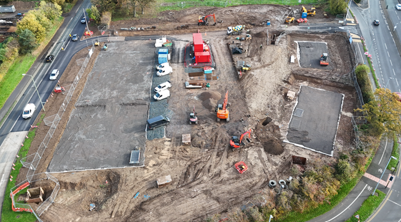
Drone Inspections
We utilise the DJI Mini 4 Pro drone to deliver high-quality aerial imagery and video for a range of property services. Our advanced drone technology enables precise roof inspection surveys, helping identify potential issues at high level without costly scaffolding or access equipment. We also capture aerial photography to monitor project progression, providing clear visual updates for clients and stakeholders. Additionally, our drone surveys assist in detecting dilapidation across properties, ensuring timely maintenance and compliance. With 4K video capability and intelligent flight features, we offer safe, efficient, and detailed monitoring solutions that enhance accuracy and reduce inspection time.